GEOGRAPHY
from Reference 13
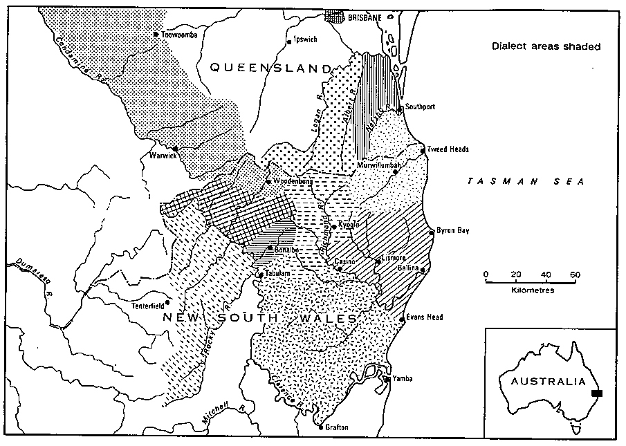
The map below indicates the extent of presumed Bundjalung occupation as described by Bundjalung people this century. Along the coast the territory stretched from somewhere north of the Clarence to somewhere north of Southport. In the upper reaches, the territory spread across the Clarence River, encompassed the Richmond River basin, and extended as far west as Tenterfield on the Tablelands in New South Wales and Allora (beyond Warwick) in Queensland. Further north there is no record of territory extending beyond the Boonah/Moogerah area.
|
| Map of area |
Apart from the Tablelands area of Tenterfield and further north, there are many mountainous areas in this section of country, many of which formed traditional territorial boundaries; a number of these were penetrable only with difficulty. Beliefs about hostile spirits in the mountains (Le. ones that belonged to no tribe or family and therefore had no allegiance) reinforced this. However there were a number of more negotiable routes, even across the McPherson Range on the New South Wales-Queensland border, which formed the biggest barrier.
Between present New South Wales and Queensland there is evidence of communication channels up the Numinbah Valley (Gresty 1946-7), and I suggest, on the basis of vocabulary similarities between Gidabal and Yugambeh. that there must have been some western routes used. Travel in the area (not as extensively as I would like, some footwork would have been invaluable) has helped in knowing about possible routes through the Border Ranges. Apart from a route well to the west (past Warwick), a route through northwest of Koreelah and Koreelah Creek towards Boonah, through the pass with the Boonah border gate, was and is open eucalypt forest and grassland, and seems quite passable.
The middle and lower reaches of the rivers were very fertile, and the climate was mild ('Summerland' the tourist maps proclaim it today). While places like Warwick and Tenterfield on the Tablelands could be very cold, with frosts and the rare snowfall (Warwick had a traditional 'cold increase' site, and Gidabal folk etymology links the name Warwick with their word waring for 'cold'), frost free times in the lower areas were quite long. Summer and autumn were the wettest times; late winter and early spring the driest (Sullivan 1965:2).
At the time of European settlement, there were basically three types of vegetation: a subtropical rain forest was far more widespread than today; much of this fertile land is now cleared, except in the mountains. The rainforest (the big scrub or gabal) reached right to the riverbanks in most places, and its past existence is responsible for the 'un-Australian', relatively eucalypt-free pastures of today in the Northern Rivers area. The rainforest extended into the McPherson Range and north to Mt Tamborine, but did not extend inland much further than Mt Lindesay. Sometimes near the rivers, further back from them, and in the higher lands, there was a mixed eucalypt forest. Along the coast there were heaths and swamps.
Possum was plentiful in the rain forest area, and their skins were used to make blankets. The nature of the rainforest precluded use of some weapons of the hunt useful in more open country; this applied to much of the eucalypt forest area in the territory also. Both animal and vegetable food was plentiful, and the Bundjalung could live a more settled life than many other groups. Fairly large buildings, some 8 to 30 feet in length and up to six feet in height were observed by early European explorers and their Aboriginal helpers. Nonetheless seasonal movements did occur as sea and land foods came into season. For at least some of the Bundjalung groups, the most extensive movement was a roughly triennial visit to the Bunya Mountains to take part in the bunya nut feasts, after which early reports are that they returned looking particularly well nourished.
Comments